
By Eneojo Herbert Idakwo
An Oral Historical, Linguistic and Ethno-Geographical Analysis
Abstract
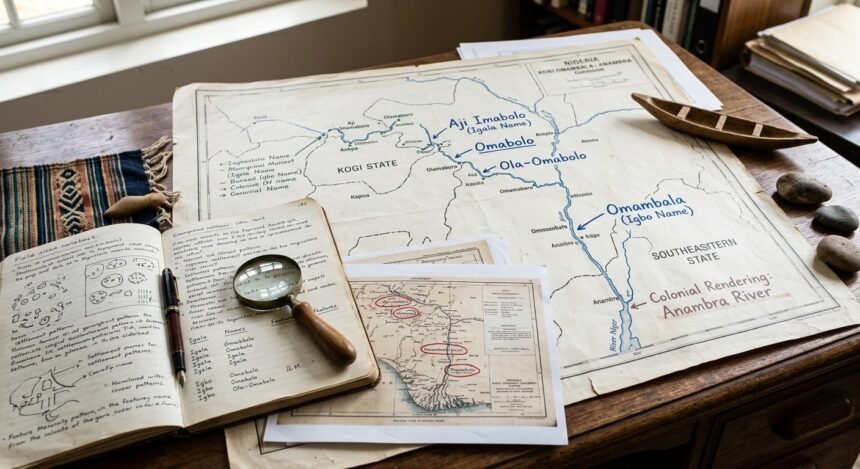
The river presently known as the Anambra River constitutes an important geographical corridor linking the upper basin around Ankpa and Olamaboro in present-day Kogi State with communities in the lower basin of southeastern Nigeria before its eventual connection with the River Niger. Despite the prominence of the colonial name Anambra, the river possesses a much older linguistic and cultural history preserved in the geographical traditions of the communities along its course. This article examines the river as a continuous hydro-cultural corridor and reconstructs the trajectory of its nomenclature from the Igala-speaking upper basin to the Igbo-speaking lower basin and subsequently into colonial cartography. It argues that Aji Imabolo is the Igala designation of the river, with Imabolo, Omabolo and Mabolo representing forms of the same Igala name. The study further establishes the relationship between the Omabolo river and Olamaboro through the Igala expression Ola-Omabolo, understood as the riverside or land beside the Omabolo. As the river continues into the Igbo-speaking lower basin, its name appears as Omambala, representing the Igbo form of the older Igala name. During the colonial period, Omambala was rendered in European records through forms including Amambara and Anambara before the modern form Anambra became standardised. The article combines oral historical interpretation, linguistic evidence, geographical studies, historical documentation and official records to examine the river’s changing nomenclature and socio-spatial significance. It finds that the changing names do not represent different rivers but successive linguistic and historical layers attached to one continuous geographical system. The Omabolo-Omambala-Anambra continuum consequently provides an important framework for understanding Igala-Igbo interaction, settlement, agriculture, fishing, trade, cultural exchange and the transformation of indigenous geographical knowledge under colonial administration.
- Abstract
- 1. Introduction
- 2. Conceptualising the River as a Hydro-Cultural Corridor
- 3. Methodological Approach
- 4. The Geography of the River
- 5. Aji Imabolo and the Igala Name of the River
- 6. Imabolo, Omabolo and Mabolo
- 7. Ola-Omabolo and the Naming of Olamaboro
- 8. The River and Igala Historical Geography
- 9. From the Igala Basin to the Igbo-Speaking Lower Basin
- 10. Omambala as the Igbo Form
- 11. Omabolo to Omambala
- 12. Omambala and Colonial Anambra
- 13. Colonial Cartography and Indigenous Geography
- 14. The River and Settlement Development
- 15. Agriculture and Fishing
- 16. Trade, Movement and Cultural Interaction
- 17. The River as a Site of Igala-Igbo Interaction
- 18. Hydro-Cultural Continuity
- 19. The Socio-Spatial Significance of the Name
- 20. The Anambra River and Historical Memory
- 21. Discussion
- 22. Conclusion
Keywords: Anambra River, Omambala, Omabolo, Imabolo, Mabolo, Olamaboro, Igala, Igbo, colonial cartography, hydro-cultural corridor, ethno-geography
1. Introduction
Rivers occupy an important place in the historical geography of human societies. They provide water, support agriculture and fishing, facilitate transportation and trade, attract settlements and frequently become reference points for defining territorial and cultural identities. For this reason, the names given to rivers are rarely merely geographical labels. They can preserve memories of settlement, migration, cultural interaction and political change.
The river now known as the Anambra River provides an important example of this relationship between geography, language and history. It rises in the upper basin around the Ankpa area, passes through the Kogi-Anambra corridor and eventually joins the River Niger. Contemporary hydrological and environmental studies confirm the physical continuity of this river system and its importance to communities along its course (Odo, 2004; Yunusa et al., 2024).

The modern name, however, represents only the latest layer in a much longer naming history.
Within Igala geographical tradition, the river is known as Imabolo, Omabolo and Mabolo. An Igala language study identifies Aji Imábolō as the Anambra River (Kigala Online, 2017). This linguistic evidence is supported by contemporary research on River Imabolo in Ankpa, which traces the river through Olamaboro and into the wider Anambra drainage system (Yunusa et al., 2024).
The significance of this evidence is considerable. It places the upper section of the river firmly within an Igala linguistic and geographical tradition.
Further downstream, the river is known as Omambala in the Igbo-speaking environment. The Anambra State Government explicitly states that the present name Anambra is a colonial pronunciation of the Omambala River (Anambra State Government, n.d.).
The central argument of this article is therefore that Imabolo, Omabolo, Mabolo, Omambala and Anambra represent different linguistic and historical forms associated with one continuous river system.
The article approaches the river not simply as a hydrological feature but as a hydro-cultural corridor, a geographical space through which communities, languages, economic activities and cultural practices interacted over time.
2. Conceptualising the River as a Hydro-Cultural Corridor
The concept of a hydro-cultural corridor provides a useful framework for examining the relationship between waterways and human society. A river is simultaneously a physical system and a human landscape. Its course determines patterns of settlement and agricultural activity, while communities living around it attach names, stories, traditions and economic practices to its waters and surrounding environment.
In the case of the Anambra River, the geographical continuity of the river provides the physical foundation for examining the linguistic continuity of its names.
The upper river corridor is associated with Igala communities and geographical names such as Imabolo, Omabolo and Mabolo. The lower basin is associated with Igbo communities and the name Omambala. The colonial period introduced European forms of the name, culminating in Anambra.
The changing nomenclature therefore provides a historical record of successive linguistic environments.
This approach is particularly important because political boundaries are relatively recent compared with the history of the river. Modern state boundaries cannot adequately explain the historical distribution of river names, settlement patterns and cultural relationships that developed long before the creation of Nigeria’s present administrative structure.
3. Methodological Approach
This article adopts an interdisciplinary qualitative approach combining oral history, historical geography, ethno-linguistics, physical geography and documentary analysis.
The linguistic dimension draws on John Idakwoji’s An Ígálá-English Lexicon, a major documentation of the Igala language containing more than 5,000 headwords and extensive discussion of Igala vocabulary, grammar, tones, dialects, history and culture (Idakwoji, 2015). Idakwoji’s work is particularly relevant because it documents Igala as spoken not only in Kogi State but also in parts of Enugu, Anambra, Delta and Benue States.
The study also uses Igala language material identifying Aji Imabolo as the Anambra River (Kigala Online, 2017).
The geographical analysis draws on scientific studies of River Imabolo and the wider Anambra drainage system. Yunusa et al. (2024), for example, identify River Imabolo in Ankpa and trace its course through Olamaboro before its connection with the wider Anambra system.
Historical and cultural evidence concerning Olamaboro and the Maboro River is also examined. Finally, official historical information from Anambra State is used to establish the modern relationship between Anambra and Omambala.
The study treats oral tradition and linguistic interpretation as important historical evidence while placing them within the broader geographical and documentary record.
4. The Geography of the River
The Anambra River is a major tributary of the River Niger. The river occupies a substantial drainage basin and forms part of the wider hydrological system of southeastern Nigeria.
Its upper course is associated with the Ankpa area of present-day Kogi State. Research on River Imabolo confirms that the river passes through Ankpa Local Government Area into Olamaboro Local Government Area before joining other waterways that contribute to the Anambra River system (Yunusa et al., 2024).
This geographical evidence is important because it establishes the physical connection between the river known locally as Imabolo and the river that is later known as Anambra.
The river is perennial in the Ankpa area and supports several forms of human activity. Yunusa et al. (2024) report domestic uses, irrigation and fishing along River Imabolo.
Research in Olamaboro similarly identifies the Maboro River as part of the area’s drainage system and describes the valley areas as characterised by alluvial soils associated with river systems (Assessment of the Quantity of Harvested Rainwater, n.d.).
The geographical evidence therefore establishes the river as a continuous environmental system with direct implications for human settlement and economic activity.
5. Aji Imabolo and the Igala Name of the River
The expression Aji Imabolo occupies a central position in the linguistic argument of this study.
Igala language material identifies:
Aji Imábolō — Anambra River (Kigala Online, 2017).
Within the Igala linguistic interpretation adopted in this study, Aji means river. Thus, Aji Imabolo identifies the geographical feature as the Imabolo River.
This provides an important distinction between the river’s indigenous Igala identity and its later colonial designation.
The significance of the name is reinforced by the independent geographical existence of River Imabolo in Ankpa. The name is therefore not merely an oral historical reference without a corresponding geographical feature. Contemporary scientific research identifies River Imabolo, studies its physical characteristics and traces its course toward the wider Anambra drainage system (Yunusa et al., 2024).
The linguistic and geographical evidence consequently converge around the identification of Imabolo as the Igala name associated with the upper course of the river.
6. Imabolo, Omabolo and Mabolo
The Igala forms Imabolo, Omabolo and Mabolo are treated in this study as forms of the same river name.
The different forms occur within the same geographical environment and are associated with the river system extending from Ankpa through Olamaboro toward the Anambra basin.
The persistence of Imabolo as the name of a physical river in Ankpa is particularly important. Yunusa et al. (2024) describe River Imabolo as passing through Ankpa and Olamaboro before connecting with the Anambra River.
Other research likewise describes Imabolo as one of the waterways associated with the wider drainage system of the area.
The form Maboro is especially significant in relation to Olamaboro. A historical study of the area states that Olamaboro derives its name from the Maboro River and traces the river to Ofejiji in central Ankpa (Gender Relations and Its Impact on the Economy of Olamaboro 1960–2020, 2026).
The convergence of these sources establishes a strong geographical relationship between:
Imabolo → Omabolo → Mabolo/Maboro → Olamaboro → Anambra River system.
The names are therefore part of the same geographical history.
7. Ola-Omabolo and the Naming of Olamaboro
One of the most important elements of the Igala oral historical interpretation is the expression Ola-Omabolo.
Within the interpretation adopted in this study, Ola-Omabolo means the riverside or land beside the Omabolo.
This expression provides an important explanation of the relationship between the river and the settlement known today as Olamaboro.
Place-names frequently emerge from the physical environment in which communities develop. A settlement beside a major river can acquire a name that preserves the identity of that river and the relationship of the settlement to it.
The Olamaboro evidence supports this interpretation. Historical research identifies the Maboro River as the source of the name Olamaboro (Gender Relations and Its Impact on the Economy of Olamaboro 1960–2020, 2026).
Research on the physical environment of Olamaboro also identifies Maboro among the drainage features of the area (Assessment of the Quantity of Harvested Rainwater, n.d.).
Olamaboro therefore provides an important geographical link between the Igala river name and the settlement landscape.
8. The River and Igala Historical Geography
The identification of Imabolo and Omabolo as Igala names for the river contributes to the understanding of the historical geography of Igala communities.
Geographical names preserve evidence of how communities understood and organised their environment. A river with an established name is not simply a physical feature. It is a recognised component of the cultural landscape.
The existence of the Imabolo name in the Ankpa area demonstrates the integration of the river into Igala geographical knowledge.
The connection with Olamaboro strengthens this conclusion. The Maboro River is directly associated with the name of the locality, while Imabolo is independently identified in scientific literature as a river extending through Ankpa and Olamaboro (Yunusa et al., 2024).
This relationship demonstrates how river names can become embedded in settlement identities.
9. From the Igala Basin to the Igbo-Speaking Lower Basin
The river continues southward from the Igala-speaking upper basin into an area dominated historically by Igbo-speaking communities.
This transition is important for understanding the change from Omabolo to Omambala.
The river did not change its geographical identity when it entered another linguistic environment. What changed was the linguistic form through which communities identified it.
Such changes are common where geographical features extend across linguistic boundaries. A river can carry different names among neighbouring communities while remaining the same river.
The Omabolo-Omambala relationship is therefore best understood as a linguistic transition associated with the movement of the river through different cultural and linguistic environments.
10. Omambala as the Igbo Form
Omambala is the established Igbo form of the river in the lower basin.
The name has remained an important geographical and cultural reference in southeastern Nigeria.
The official history of Anambra State provides particularly important evidence. The state government states that the state derives its name from the Anambra River and describes Anambra as a colonial convenient pronunciation of Omambala River (Anambra State Government, n.d.).
This official statement provides a direct connection between the modern name and the older Omambala form.
Within the historical framework of this study, Omambala represents the Igbo form of the older Igala river name Omabolo.
The change is therefore interpreted as a linguistic adaptation occurring within the Igala-Igbo contact zone.
11. Omabolo to Omambala
The transition from Omabolo to Omambala is central to the historical argument.
The relationship can be represented as:
Igala: Omabolo
Igbo: Omambala
The river’s geographical continuity provides the foundation for understanding this relationship.
The river passes from the Igala-speaking upper basin into the Igbo-speaking lower basin. Its name therefore moves with it but assumes a form appropriate to the downstream linguistic environment.
This process reflects the broader relationship between language and geography. Communities inherit geographical features but interpret them through their own linguistic systems.
Consequently, the change from Omabolo to Omambala should not be understood as evidence that two different rivers are being described. Rather, it represents the linguistic adaptation of one geographical identity.
12. Omambala and Colonial Anambra
The final major transformation in the river’s naming history occurred during colonial rule.
European explorers, missionaries and cartographers encountered indigenous geographical names and recorded them through European linguistic and orthographic conventions.
Historical records contain forms such as Amambara and Anambara before the modern form Anambra became standardised.
The significance of these forms is that they demonstrate a transition rather than an abrupt creation of a new name.
The Anambra State Government confirms this relationship by describing Anambra as a colonial pronunciation of Omambala River (Anambra State Government, n.d.).
The naming sequence can therefore be expressed as:
Omambala → colonial renderings → Anambra.
Anambra subsequently became the dominant official form through colonial maps, administrative records and the later political geography of Nigeria.
The process illustrates the power of colonial administration to standardise indigenous geographical names.
13. Colonial Cartography and Indigenous Geography
Colonial cartography played an important role in fixing the modern geographical vocabulary of Nigeria.
Before colonial mapping, geographical knowledge was transmitted primarily through local languages and oral traditions. European mapping converted this knowledge into written cartographic forms.
The transformation of Omambala into Anambra should therefore be viewed within this wider history of colonial mapping.
The colonial record did not create the river. It created an official written form of its name.
This distinction is important.
The physical river existed before colonial administration. The Igala name Imabolo existed before colonial cartography. The Igbo name Omambala existed before the modern administrative state. What colonial administration did was to record, modify and eventually standardise the name as Anambra.
The modern name therefore represents the colonial layer of a much older geographical history.
14. The River and Settlement Development
The river has played an important role in the development of settlements along its course.
Water availability is a fundamental determinant of settlement. Communities require water for domestic consumption, farming, fishing and livestock.
The fertile soils associated with river valleys also encourage agricultural settlement.
The Olamaboro area provides a clear example. The Maboro River forms part of its drainage system, while agriculture remains an important economic activity in the locality (Assessment of the Quantity of Harvested Rainwater, n.d.; Gender Relations and Its Impact on the Economy of Olamaboro 1960–2020, 2026).
The same relationship between river and settlement appears throughout the lower Anambra basin.
Riverine settlements consequently developed around access to water, agricultural land and aquatic resources.
15. Agriculture and Fishing
Agriculture and fishing have historically formed important components of the economy of communities along the river.
Research on River Imabolo identifies irrigation and fishing among the uses of the river (Yunusa et al., 2024).
The river also provides water for domestic activities, demonstrating its importance beyond commercial production.
The broader Anambra basin similarly supports agricultural and fishing activities.
The economic relationship between communities and the river reinforces the argument that the river functioned as a socio-economic corridor.
Its significance was therefore not limited to naming and cultural identity. It was directly connected to livelihood.
16. Trade, Movement and Cultural Interaction
Rivers have historically facilitated movement between communities.
The connection of the Anambra River with the Niger places it within a much larger network of inland waterways.
The River Niger historically served as an important transportation and commercial route across large parts of West Africa. Tributaries connected inland settlements to this wider network.
The Anambra River consequently provided a geographical route through which communities could interact.
Such interaction created opportunities for the movement of agricultural products, fish and other commodities, as well as the movement of people and cultural ideas.
This wider interaction provides an important context for understanding why geographical names could travel across linguistic boundaries.
17. The River as a Site of Igala-Igbo Interaction
The Omabolo-Omambala-Anambra corridor provides a useful geographical framework for examining historical interaction between Igala and Igbo communities.
The river crosses linguistic space without respecting the boundaries that later became administrative boundaries.
Its upper course is associated with Igala names. Its lower course is associated with Igbo naming. Its modern official name reflects the influence of colonial administration.
The river consequently contains three major historical layers:
- Igala geographical identity
- Igbo linguistic adaptation
- Colonial cartographic standardisation
These layers do not necessarily represent periods in which one identity completely replaced another. Rather, they demonstrate how different communities interacted with the same geographical feature.
18. Hydro-Cultural Continuity
The concept of hydro-cultural continuity is useful for bringing these strands together.
The physical river has remained continuous while the human meanings attached to it have changed.
The river has:
- supported settlement;
- provided water;
- sustained agriculture;
- supported fishing;
- facilitated movement;
- connected communities;
- acquired different linguistic names;
- survived changes in political administration.
The continuity of the river therefore provides a stable geographical framework against which historical change can be examined.
Its names function as linguistic markers of those changes.
19. The Socio-Spatial Significance of the Name
A river name is a spatial marker.
When a community names a river, it establishes a relationship between language and landscape. The name becomes part of the community’s mental map.
The Igala name Imabolo places the river within Igala geographical knowledge.
The Igbo name Omambala places the same river within Igbo geographical knowledge.
The colonial name Anambra places it within the cartographic and administrative system established by colonial rule.
Each name therefore represents a different way of locating the river within a social and political geography.
The name changes, but the geographical referent remains.
20. The Anambra River and Historical Memory
The survival of multiple names demonstrates the durability of geographical memory.
Colonial administration established Anambra as the dominant official name, but the older names did not disappear completely.
Imabolo and Omabolo remain associated with Igala geographical tradition and the upper river system. Omambala remains embedded in the cultural and historical identity of the lower basin.
This persistence demonstrates that official naming does not necessarily erase indigenous geographical memory.
Instead, different layers can coexist.
21. Discussion
The evidence examined in this article supports an integrated understanding of the Omabolo-Omambala-Anambra corridor.
First, the geographical continuity of the river is established by physical and environmental studies. River Imabolo is documented in Ankpa and is connected through Olamaboro to the wider Anambra system (Yunusa et al., 2024).
Second, linguistic evidence identifies Aji Imabolo as the Igala designation of the Anambra River (Kigala Online, 2017).
Third, the Olamaboro evidence connects the locality to the Maboro River, providing an additional geographical link between the river and settlement (Gender Relations and Its Impact on the Economy of Olamaboro 1960–2020, 2026).
Fourth, the lower river is identified as Omambala, while the official history of Anambra State explicitly describes Anambra as a colonial pronunciation of Omambala River (Anambra State Government, n.d.).
These strands produce a coherent historical sequence:
Imabolo/Omabolo/Mabolo → Omambala → Anambra.
The sequence demonstrates how one geographical feature can acquire different names as it moves across linguistic and political environments.
The importance of the argument is therefore broader than the etymology of a single river. It concerns the relationship between language, territory and historical memory.
The river provides a physical connection between the Igala and Igbo worlds. Its names provide a linguistic record of that connection.
22. Conclusion
The Anambra River possesses a history that is considerably older than its modern official name.
Within Igala geographical tradition, the river is known as Aji Imabolo, with Imabolo, Omabolo and Mabolo representing forms of the same Igala river name. Contemporary scientific research independently confirms the existence of River Imabolo in Ankpa and its connection through Olamaboro to the wider Anambra drainage system (Yunusa et al., 2024).
The relationship between the river and Olamaboro is particularly significant. The locality is historically associated with the Maboro River, while the Igala expression Ola-Omabolo preserves the relationship between the settlement and the Omabolo river.
As the river continues into the Igbo-speaking lower basin, its name becomes Omambala. The name represents the Igbo form of the river’s earlier Igala identity.
The colonial period introduced another layer. European records rendered the indigenous name through forms such as Amambara and Anambara before Anambra became the standard form. The official history of Anambra State confirms that Anambra is a colonial pronunciation of Omambala River (Anambra State Government, n.d.).
The historical trajectory can consequently be represented as:
Aji Imabolo → Imabolo → Omabolo → Mabolo/Maboro → Omambala → Amambara/Anambara → Anambra.
This sequence represents different linguistic and historical layers of one geographical system.
The river remained physically continuous while its name changed according to the linguistic and administrative environment through which it passed.
The study therefore concludes that the Omabolo-Omambala-Anambra corridor should be understood as a hydro-cultural corridor linking Igala and Igbo historical spaces.
Its significance lies not only in its physical geography but also in its role in settlement, agriculture, fishing, trade, mobility and cultural interaction.
The river carries a history of linguistic contact.
Its names preserve the memory of that contact.
The modern name Anambra represents the colonial and administrative layer of that history, while Omambala preserves the Igbo layer and Imabolo, Omabolo and Mabolo preserve the Igala layer.
The river therefore demonstrates how geographical features can preserve historical relationships long after political boundaries and administrative systems have changed.
References
Anambra State Government. (n.d.). Anambra history. Anambra State Government. Anambra State Government
Idakwoji, J. (2015). An Ígálá-English lexicon: A bilingual dictionary with notes on Igala language, history, culture and priest-kings. Partridge Publishing Singapore. Google Books record for An Ígálá-English Lexicon
Kigala Online. (2017, March 26). Igala language study series. Kigala Online. Igala Language Study Series
Yunusa, A., Yusuf, A., & Abdulsalam, Z. O. (2024). Analysis of physico-chemical parameters of River Imabolo, Ankpa Local Government Area, Kogi State, Nigeria. Nigerian Journal of Animal Production, 339–342. https://doi.org/10.51791/njap.vi.4771 (mail.njap.org.ng)
Assessment of the quantity of harvested rainwater in Igah communities of Olamaboro Local Government Area of Kogi State, Nigeria. (n.d.). International Journal for Research in Applied Science & Engineering Technology. (ijraset.com)
Gender relations and its impact on the economy of Olamaboro 1960–2020. (2026). (researchgate.net)