

By Tdka Maat Kilimanjaro
Our family went to Ghana and Senegal years ago. I kept extensive journals. It took over a decade to even look at them again after beginning to appreciate the murderously filthy level of coordination and cooperation of these garbage enslavers and the collaborating degenerate Blacks. It still sickens me the level of degenerate behavior these garbage enslavers organized, and our own people’s collaboration in it.
And only three African nations have apologized from the level of government, with Uganda leading the way. Just despicable…
I only started to think about reopening my research last year when Ghana’s president spoke at the United Nations. My first thought was why not get Namibia or Botswana to deliver this speech given their populations had nothing to do with enslaving innocent Africans and shipping them around the world. Ghana territories had 100s of years of this despicable enslaver decadence. I’ve held my tongue. But I intend to bring my notes to the level of a position paper, then scientific study in time. Below is a summary of that beginning outline using data from SlaveryVoyages.
ANALYSIS
It is also important to distinguish three things: the African regions from which captives originated; African states, rulers, merchants, armies, and intermediaries who captured or sold some of those people; and the external European, Arab, North African, Persian, Ottoman, American, and other merchants who purchased and transported them. These categories overlap but are not identical. Captives could be seized hundreds of miles mainland, transferred through several African intermediaries, and finally sold at a coastal or Saharan market. This slavery selling was a diabolical mess is my point…
The much larger African geography of slave export
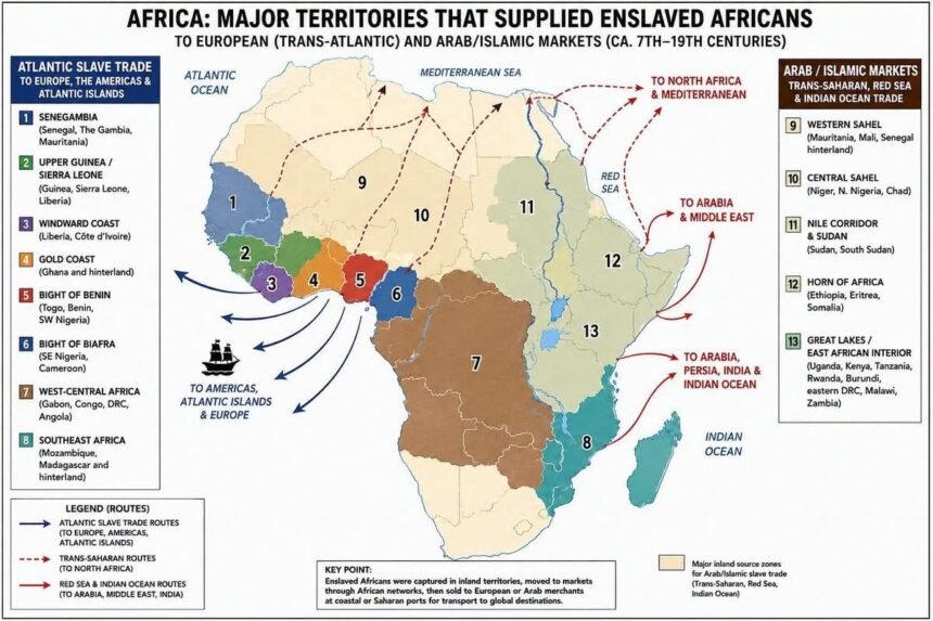
African captives were exported through four major interconnected systems over different periods:
Trans-Saharan → North Africa and Mediterranean
Red Sea/Nile → Egypt, Arabia and Middle East
Indian Ocean/East African → Arabia, Persian Gulf, India and Indian Ocean islands
Atlantic → Europe, Atlantic islands and the Americas
These systems stretched across a very large portion of Africa. Enslaved Africans were moved down the Nile, across the Sahara, across the Red Sea, and outward from the East African coast long before the Atlantic system developed. It just shows how rotten Blacks have been in helping these Arabs and later European enslaving degenerates to literally rip Africa apart mass murdering millions.
1. Senegambia and the western Sahel
This broad source zone included areas in or connected with present-day Senegal, Gambia, Mauritania, Mali and Guinea-Bissau, with networks extending inland.
Important historical political formations included Jolof, Waalo, Cayor, Baol, Futa Toro, Kaabu and neighboring Mandinka/Mande states and communities.
Captives came from warfare, political conflicts, judicial enslavement, kidnapping and raids. African merchants transported captives toward such Atlantic outlets as the Senegal and Gambia river systems and Gorée. Other captives moved northward through Saharan networks.
SlaveVoyages classifies Senegambia as one of eight major Atlantic embarkation regions.
2. Upper Guinea and Sierra Leone
This zone encompassed parts of today’s Guinea-Bissau, Guinea, Sierra Leone and neighboring Liberia.
Captives moved through riverine and coastal trading networks involving numerous African societies and commercial intermediaries. Atlantic embarkation areas included Cacheu, Rio Pongo, Sierra Leone, Sherbro and neighboring ports and rivers.
SlaveVoyages separates this into its Sierra Leone region, running approximately from the Rio Nunez to Cape Mount.
3. Windward Coast
This covered principally modern Liberia and western Côte d’Ivoire, with connections into the interior.
Rather than one centralized state controlling the entire commerce, numerous African commercial networks participated at different times. European vessels purchased captives at multiple coastal locations.
SlaveVoyages defines the historical Windward Coast roughly from Cape Mount to the Assini River.
4. Gold Coast — present-day Ghana and neighboring areas
Modern Ghana became an important Atlantic slave-export region, particularly during the seventeenth and eighteenth centuries.
Major African political actors at different times included Asante, Fante states and alliances, Akwamu, Denkyira, Akyem and other Akan and neighboring polities.
Major European-controlled coastal trading installations included Elmina, Cape Coast, Anomabu and numerous other forts and trading posts.
Anomabu, for example, became a major British slave-trading center.
There is an important chronological qualification: the Gold Coast initially imported enslaved labor from elsewhere because its gold-producing economy required labor. It subsequently became a major exporter during the Atlantic era.
5. Bight of Benin — the so-called “Slave Coast”
This was one of the most intensive Atlantic exporting regions and included areas of present-day Togo, Benin and southwestern Nigeria, with hinterland connections farther north.
Major political formations included:
Kingdom of Dahomey
Oyo Empire
Kingdom of Allada
Kingdom of Whydah/Hueda
and numerous Yoruba, Aja, Fon and neighboring political communities.
Important embarkation points included Ouidah/Whydah, Porto-Novo, Lagos and nearby coastal outlets.
Wars between African states, expansion of Oyo and Dahomey, political conflicts, raiding and commercial demand generated large captive populations. European merchants—particularly Portuguese/Brazilian, British, French and Dutch traders at different periods—purchased captives along the coast.
SlaveVoyages defines the Bight of Benin as the Atlantic region from approximately the Volta River to the Rio Nun.
6. Bight of Biafra
This encompassed southeastern Nigeria, parts of Cameroon, and associated hinterlands.
Important embarkation centers included:
Bonny
Old Calabar
New Calabar
Brass
Captives included people from Igbo, Ibibio, Efik and numerous neighboring populations, although ethnic identity must not be confused with responsibility for enslavement.
Commercial systems here were often decentralized. African merchant houses and brokers transported captives from inland markets to coastal trading centers, where Europeans purchased them.
SlaveVoyages identifies the Bight of Biafra as one of the eight principal Atlantic embarkation regions.
7. West-Central Africa — the largest Atlantic source region
This is indispensable to a corrected map.
It included much of present-day Gabon, Republic of Congo, Democratic Republic of Congo and especially Angola, with extensive inland catchment areas.
Important historical political formations included:
Kingdom of Kongo
Ndongo
Matamba
Kasanje
Lunda
and numerous smaller states and communities.
Major Atlantic ports included:
Luanda
Benguela
Cabinda
Loango
Portugal and Portuguese America/Brazil developed particularly powerful commercial and colonial connections with this region.
This is why the Angola → Brazil connection must be prominent on any serious map of the Atlantic slave trade.
SlaveVoyages identifies West-Central Africa as the largest regional departure point for captives during much of the Atlantic slave-trade era. This is about right.
8. Southeastern Africa and Mozambique
The Atlantic system eventually extended around the Cape into southeastern Africa.
The principal modern territories involved were Mozambique and Madagascar, with networks penetrating areas corresponding to parts of present-day Malawi, Zambia, Zimbabwe and Tanzania.
Mozambique Island, Quelimane and other ports became important outlets. Captives could be shipped through either the Atlantic system toward the Americas or through the Indian Ocean system.
SlaveVoyages therefore treats Southeast Africa as a separate Atlantic embarkation region.
The Arab/Islamic-market systems require an entirely different eastern and northern layer
A corrected map cannot simply extend the Atlantic map eastward. The chronology and organization were different.
From roughly the early Islamic centuries onward, major external slave markets existed in North Africa, Egypt, Arabia, the Persian Gulf and parts of Asia. Routes crossed the Sahara, Nile corridor, Red Sea and Indian Ocean.
The zone of greatest importance during 1400–1600 extends along the southern Sahara, Red Sea shores and East African coast, with many captives originating farther inland. They marched innocent Black men, women and children sometimes 100s of miles.
9. Western and Central Sudan/Sahel
Areas within today’s Senegal, Mauritania, Mali, Burkina Faso, Niger, northern Nigeria and Chad were connected to trans-Saharan slave-trading systems at various periods.
Important historical states included:
Ghana/Wagadu
Mali
Songhai
Kanem-Bornu
Hausa states
Routes ran toward major North African commercial centers through places such as Sijilmasa, Ghadames, Ghat, Fezzan, Tripoli and other Saharan corridors.
Participation varied dramatically by century and polity. These states should therefore not simply be colored uniformly as though modern countries had a single continuous policy.
10. Lake Chad and Central African interior
The Lake Chad basin became an especially important connection between sub-Saharan Africa and the Sahara.
The Kanem-Bornu political-commercial system participated in networks linking the Lake Chad basin to Fezzan and North Africa.
Captives could originate in surrounding regions corresponding to parts of modern Chad, Cameroon, Nigeria, Niger, Central African Republic and Sudan.
11. Sudan and the Nile corridor
The Nile provided another major northward forced-migration corridor.
Regions corresponding to modern Sudan and South Sudan supplied captives into networks running northward toward Egypt and northeastward toward the Red Sea.
The history here extends well before Islam, so it would be incorrect to label every Nile slave movement an “Arab slave trade.” Cambridge notes very ancient movements of captives through the Nile system, followed much later by expansion under Islamic commercial systems.
12. Ethiopia, Eritrea and the Horn
Areas corresponding to Ethiopia, Eritrea, Somalia and neighboring regions participated in Red Sea and Indian Ocean slave systems in different ways and at different periods.
Routes connected inland markets with Massawa, Zeila, Berbera and other Red Sea/Gulf of Aden ports, then with Arabia and the broader Middle Eastern market.
Ethiopia, Nubia, Egypt, Yemen and East Africa are explicitly among the regions Cambridge identifies in the western Indian Ocean/Red Sea slave system.
13. East African interior
The East African slave trade eventually reached deeply into territories corresponding to modern:
Tanzania
Kenya
Uganda
Rwanda
Burundi
eastern Democratic Republic of Congo
Malawi
northern Mozambique
Zambia
This became especially extensive during the eighteenth and nineteenth centuries.
Caravan networks transported captives toward the Swahili coast. Zanzibar became an exceptionally important nineteenth-century commercial center, connected with mainland routes reaching toward the Great Lakes and Congo basin.
The crucial point is that many captives exported from an East African port were not inhabitants of that coastal territory. They had been captured or purchased far inland and forced along caravan routes.
14. Mozambique
Mozambique belongs to both the Atlantic and Indian Ocean stories.
Captives from Mozambique and its hinterland were transported toward Indian Ocean destinations, while substantial numbers were eventually transported across the Atlantic, particularly during the later slave trade.
Its catchment extended beyond modern Mozambique into parts of Malawi, Zambia and Zimbabwe.
15. Madagascar
Madagascar also occupied an unusual position.
Different Malagasy kingdoms and political factions captured, enslaved, imported and exported people at different periods. Madagascar participated in the western Indian Ocean economy and also supplied captives to European colonial plantation economies.
Thus Madagascar should appear on a comprehensive African map rather than being left blank.
What a historically accurate map should show
Rather than coloring whole modern countries as either “guilty” or “not guilty,” I would construct the map using historical source zones and routes.
The Atlantic component alone was geographically enormous. Slave Voyages divides African embarkation into eight major coastal regions: Senegambia, Sierra Leone, Windward Coast, Gold Coast, Bight of Benin, Bight of Biafra, West-Central Africa and Southeast Africa. West and West-Central Africa supplied the majority of people carried into the Atlantic system, while West-Central Africa was the single largest regional departure zone through much of its history.
Finally, the coast was often the point of sale or embarkation, not the point of capture. European ships generally operated from coastal ports, forts, rivers and roadsteads, while African wars, raiding networks, states, merchants and intermediaries could move captives from far into the interior. Similarly, trans-Saharan and Indian Ocean systems connected interior African capture zones to distant North African, Arabian and Asian markets. Consequently, the historical geography is better represented as a capture → inland market → forced march/caravan → coastal/Saharan market → external purchaser → transport → destination process rather than simply coloring present-day countries.
Some in-boxed me about my inferences about modern African societies that directly helped White and Arabs enslavers destroy the lives of 100s of millions of innocent enslaved over the centuries.
I said those African nations first should redeem themselves with reparations of land and citizenship to Africans in the diaspora. Whether the degenerate enslavers paid reparations or not. How did I get this position?
CONCLUSIONS
When in Ghana in the early 2000s, I kept an entire journal, front and back on that society. It’s history, economy, political system, educational system, social system, cultural system, infrastructure, stage of technological development, military, legal system and moral system.
I planned a comprehensive case study of the development of western Africa similar to our book, BAK2 and its focus on North America’s development. But then I went into the slavery dungeons. Fort James. Elmina. Etc. It convinced me I had been wrong and on the wrong path. The devil was in the details. Sure the Whites and Arabs caused this murderous slave holocaust. But how were they able to enslave so many millions of Blacks for so long with such ease?
Got back to the United States. Began serious research in University of Michigan and Michigan State libraries and the Library of Congress. My focus changed once I saw with my own eyes that for centuries Black tribal chiefs had been actually collaborating with and even assisting these rotten White and Arab enslavers. Going inland to Kamausi Ghana proved this to me. Leasing land, burning villages, hunting and helping to capture, then marching innocent men, women, and children to the coastal slave dungeons set up by the Whites and Arabs for 100s of years. Built with Black labor. Over a 1400 years for Arabs.
This revelation, an epiphany of sorts, changed the course of my life. I had not written a single book. But I knew from this journey and journal that the resolution of our crippled situation was not external, but was internal. So our entire 33 book system had to be conceptualized to address our internal mental, moral and martial deficiencies first and foremost.
We are at the center of why with such ease other populations run over us—as we cut rotten deals and help them every step of the way.
I jettisoned the 50+ year literature of complaining. We must get our own house in order…internally.