

By Okoi Obono-Obla
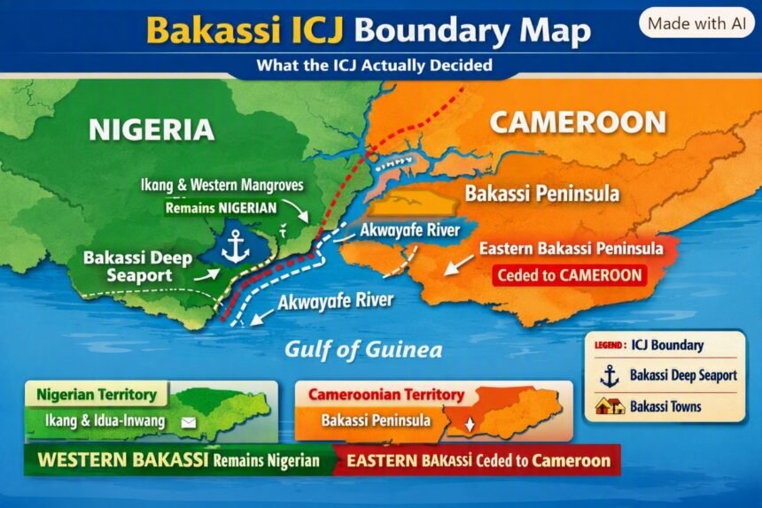
The judgment of 10 October 2002 ceded only the peninsula east of the Akwayafe thalweg to Cameroon. Ikang and the western mangroves where the Bakassi Deep Seaport sits remain Nigerian by the same verdict.
I belong to a WhatsApp platform hosted by Moderator Matto — a Nigerian based in the United States, with members from Europe, the diaspora, and selected Nigerians at home. It is an intellectual gathering of accomplished professionals from all walks of life: politicians, writers, lawyers, engineers, academics, journalists and those in the health sciences.
Last night I woke to see a conversation on the Bakassi Peninsula. Some contributors argued that the judgment of the International Court of Justice gave everything concerning Bakassi to the Republic of Cameroon and left nothing for the Federal Republic of Nigeria.
With respect, that view shows the writer has not read the judgment. I am from Cross River State and Counsel to one of the indigenous groups in Bakassi after the ICJ Judgment. I have a fairly good knowledge of the ecosystem.
As the celebrated judgment will be 24 years old on 10th October 2026, I returned to the archives of the ICJ to summarize what the Court actually decided — in lucid language devoid of legalese.
THE JUDGMENT
The case is Land and Maritime Boundary between Cameroon and Nigeria: Equatorial Guinea Intervening. Judgment was delivered at The Hague on 10 October 2002.
On the Bakassi question, the Court held:
The boundary in Bakassi is delimited by Articles XVIII-XX of the Anglo-German Agreement of 11 March 1913.
Sovereignty over the Bakassi Peninsula as defined by that Agreement lies with Cameroon.
The boundary follows the thalweg of the River Akpakorum (Akwayafe), dividing the Mangrove Islands near Ikang in the way shown on British Admiralty Chart TSGS 2240, as far as a straight line joining Bakassi Point and King Point.
PLAIN ENGLISH
What is a thalweg? The line connecting the deepest points along a navigable river channel.
Where is the Akwayafe River? The Akwayafe, also known as Akpakorum or Akpa Yafe, empties into the Bight of Biafra, in the Gulf of Guinea. It forms part of the land boundary between Nigeria and Cameroon.
WHAT THIS MEANS
The ICJ ceded to Cameroon only the peninsula EAST of the thalweg of the Akpakorum. It did NOT cede the area WEST of the thalweg. The mangrove islands on the western side, facing Ikang, remain Nigerian by the same judgment.
TWO HISTORICAL CORRECTIONS
1. The Handover was not in 2002. The judgment was implemented through the Greentree Agreement signed on 12 June 2006 by Presidents Olusegun Obasanjo and Paul Biya under UN Secretary-General Kofi Annan. Final transfer of authority was completed on 14 August 2008.
2. Bakassi LGA and the Deep Seaport. Bakassi Local Government Area still exists under the 1999 Constitution. Its headquarters is now at Ikang — often referred to as Ekpri Ikang.
The Bakassi Deep Seaport being developed by Cross River State and the Federal Government is located at Idua-Inwang village in Esighi community, Bakassi Local Government Area — on the Nigerian side of the ICJ line, not on the ceded peninsula.
CONCLUSION
The Bakassi Peninsula as defined in 1913 and affirmed by the ICJ in 2002 is Cameroonian. Western Bakassi — including Ikang and its offshore waters where the deep seaport is sited — remains Nigerian by that same judgment.