

By Cross River Economic Intelligence Team (CREIT) @2026
1. The River Cross River Is Not Cross River State
The Cross River is an international transboundary river, rising in the Cameroon Highlands and flowing approximately 485 km through Cameroon and Nigeria—about 160 km in Cameroon and 325 km in Nigeria—before discharging into the Atlantic Ocean/Gulf of Guinea.
It is therefore essential to distinguish the River Cross River from Cross River State, the Nigerian territorial entity through which a substantial part of the river flows. The wider Cross River drainage basin extends across both Nigeria and Cameroon, with approximately 74% of the basin in Nigeria and 26% in Cameroon.
The Cross River’s annual runoff to the sea is approximately 52 billion cubic metres (52 km³), equivalent to an average annual discharge of roughly 1,650 m³/s.
2. The River Cross River Does NOT Flow Through Itu (Local River) as a Tributary into the Atlantic Ocean
The Cross River is a connected river-basin and estuarine system, not a single channel dependent on the Itu River for access to the Atlantic Ocean. Its lower system incorporates the Cross River, Calabar River, Great Kwa, Akpa-Yafe and Mbo waterways, together with interconnected tidal channels. The Cross River Estuary empties into the Atlantic Ocean at the Bight of Biafra, Gulf of Guinea, forming an important eastern maritime gateway of Nigeria into the Gulf of Guinea.
The wider basin extends into Nigeria and Cameroon and interacts with coastal waters adjoining Akwa Ibom. A 2025 study recorded approximately 8.38 km from the Cross River Estuary mouth to the Atlantic, compared with approximately 98.9 km at the Itu Beach station, demonstrating the distinct geographical relationship between the Cross River Estuary and the Itu corridor.
3. The Judgment of the International Court of Justice on the Eastern Bakassi Boundary Was Based on the Interpretation and Application of Historical Boundary Instruments; the Maroua Declaration Was Not a Colonial Treaty
The 10 October 2002 Judgment of the International Court of Justice (ICJ) in Land and Maritime Boundary between Cameroon and Nigeria determined the Bakassi boundary primarily through the interpretation and application of the Anglo-German Agreement of 11 March 1913, particularly Articles XVIII–XX, together with other relevant historical boundary instruments, including the Thomson-Marchand Declaration and subsequent agreements and declarations.
The Court held that, in the Bakassi area, the boundary followed the thalweg of the Akpakorum (Akwayafe) River, dividing the Mangrove Islands near Ikang, as specified in the judgment. Sovereignty over the Bakassi Peninsula was determined to lie with Cameroon.
For the maritime boundary, the Court also relied upon the conventional delimitation already agreed between the two States up to Point G, including the Yaoundé and Maroua instruments, and applied the relevant provisions of the 1982 United Nations Convention on the Law of the Sea (UNCLOS) beyond Point G, particularly Articles 74 and 83 concerning the delimitation of the exclusive economic zone and continental shelf.
4. Nigeria Did Not Lose Any Oil Wells to Cameroon as a Result of the 2002 ICJ Judgment
Nigeria did not, by the 2002 ICJ judgment, simply “lose” oil wells to Cameroon. The judgment determined the land and maritime boundary between the two States, including the course of their maritime boundary within the scope of the Court’s jurisdiction.
It did not adjudicate Nigeria’s internal estuarine systems or alter the underlying geological architecture of Nigeria’s continental shelf. In relation to maritime delimitation, the Court applied the relevant principles of UNCLOS, including Articles 74 and 83, while addressing the need to respect existing rights to explore and exploit continental-shelf resources in the circumstances identified by the Court.
> “A boundary judgment determines jurisdictional limits; it does not rewrite the geology, estuaries or natural architecture of the Nigerian continental shelf.”
5. Oil Is Not Produced from a Mere Body of Water or the Flow of a Local River
Oil is not produced from a mere body of water or from the flow of a local river such as the Itu River into the Atlantic Ocean.
River flow and bodies of water are hydrographic features; the occurrence and production of petroleum depend on the underlying geological architecture and petroleum system, including sedimentary basins, source rocks, reservoir rocks, seals, traps, hydrocarbon generation and migration.
Thus, the existence of a river, estuary or coastal water body does not, by itself, establish the presence of oil wells—as illustrated by the fact that not every river or coastal water body contains producing oil wells.
Water movement may influence tidal dynamics, ocean circulation, sediment transport and deposition, which can contribute to geological processes associated with hydrocarbon migration and accumulation over geological time, but it is not itself the source of petroleum production.
> “Oil wells are produced from petroleum-bearing geological formations—not from rivers or bodies of water. River flow explains hydrography; oil production depends on the geological petroleum system beneath the land and continental shelf.
6. The Supreme Court Judgment of 2012 Did Not Transfer the 76 Oil Wells from Cross River State to Akwa Ibom State
The Supreme Court judgment of 10 July 2012 in Attorney-General, Cross River State v. Attorney-General of the Federation & Anor., SC.250/2009, did not cede or transfer the 76 oil wells to Cameroon or transfer them from Cross River State to Akwa Ibom State.
The case concerned Cross River State’s claim to 13% derivation revenue from the 76 offshore oil wells and the legal consequences of the loss of its littoral-state status following the implementation of the Green Tree Agreement and the ICJ judgment on Bakassi.
The Green Tree Agreement was principally an instrument for the transfer of territory and the establishment of a humanitarian and implementation framework; it did not itself constitute a fresh maritime-boundary delimitation by coordinates.
While the Court held that Cross River State could no longer claim littoral-state status in the circumstances before it, the question of attribution of the relevant oil wells for derivation purposes remained connected to the determination of their location within the applicable maritime jurisdiction.
The lead judgment of Adekeye, JSC, stated:
> “The 13% derivation revenue on the 76 oil wells offshore between Akwa Ibom State and Cross River State must continue to be attributed to the State on whose maritime territory they are found…” — Adekeye, JSC, leading judgment, 10 July 2012.
Yet, according to the position advanced by CREIT, the relevant inter-agency verification was not comprehensively resolved between 2012 and 2024. When subsequent verification exercises were eventually undertaken, the resulting reports had not, according to the information available to CREIT, been finally forwarded to Mr. President for approval.
7. Cross River State’s Littoral Status and Maritime Access Have Been Supported by Nigerian Hydrographic and Navigational Evidence.
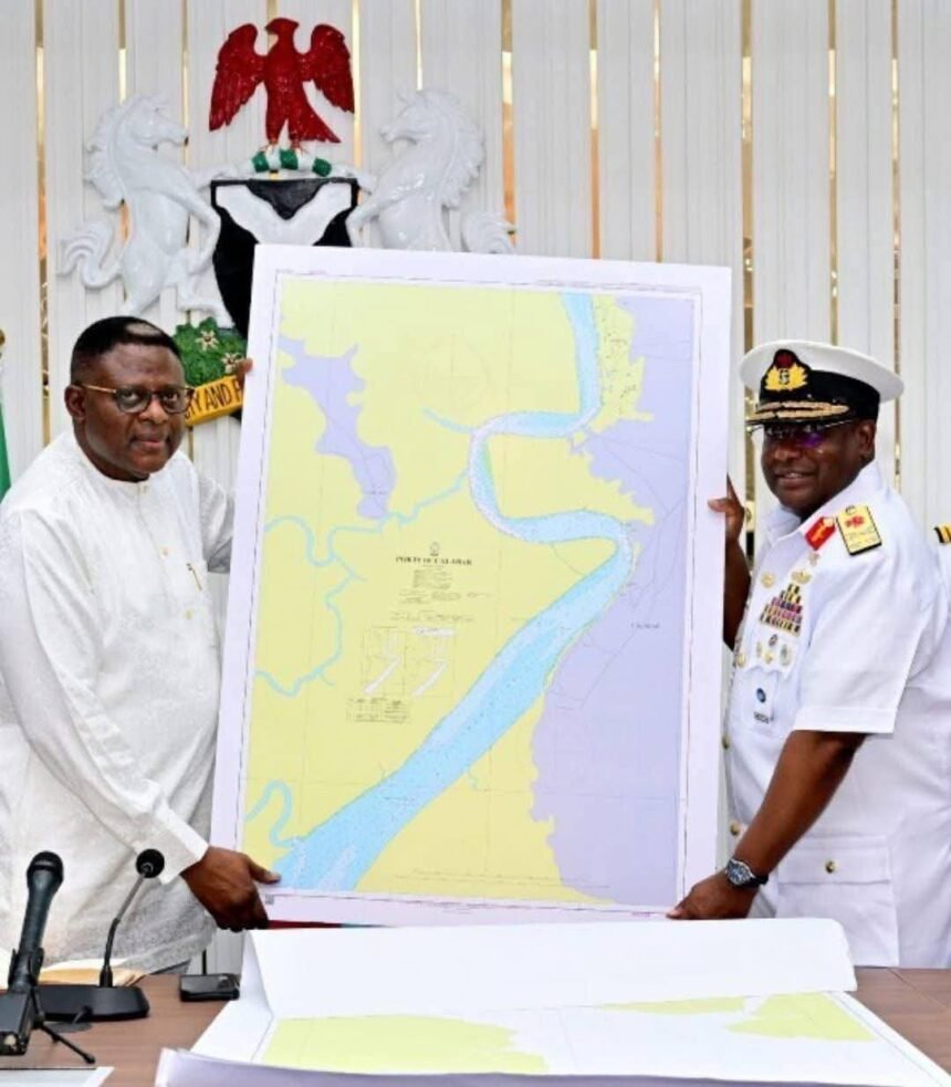
Cross River State’s littoral access and the connection of the Cross River estuarine system to the Atlantic Ocean have been addressed through Nigeria’s hydrographic and navigational framework, including the Calabar International Navigational Channel reflected in British Admiralty charting.
The channel forms part of Nigeria’s eastern maritime navigational environment in the Gulf of Guinea and its continuing navigational use demonstrates the practical maritime significance of the Calabar coastal corridor.
The continued operation of the Calabar International Navigational Channel and the Federal Government’s utilisation of the channel provide practical evidence of Nigeria’s continuing maritime access and navigational interests through the Cross River coastal environment.
> “The Calabar Navigational Channel is not merely a historical charted waterway; its continuing operation demonstrates Nigeria’s enduring maritime access through the Cross River coastal corridor into the Gulf of Guinea.”
8. Cross River State Is an Oil-Producing State with Offshore and Onshore Gas- and Crude-Bearing Reservoir Coordinates
In line with the issues arising from the 2012 Supreme Court judgment, Cross River State has facilitated three separate scientific, hydrographic, geological and maritime documentary exercises, while inter-agency records provide a continuing basis for examining the State’s petroleum interests and derivation entitlement.
The 2004 Presidential Committee Final Report under President Olusegun Obasanjo identified 76 oil wells attributable to Cross River State for derivation purposes.
The 2024 Inter-Agency Committee Report subsequently confirmed 67 oil wells, while the 2025 Inter-Agency Committee Report recorded 119 oil wells as the allocation attributable to Cross River State.
Following the presentation by Governor Senator Prince Bassey Edet Otu of scientific, maritime, geological and legal evidence concerning Cross River State’s petroleum assets and derivation entitlement, President Bola Ahmed Tinubu mandated the Senate President, Senator Godswill Akpabio, to facilitate an amicable resolution of the outstanding oil-wells issue between Cross River State and Akwa Ibom State.
Consequently, the two States have engaged in consultations, and the two Governors have constituted a joint subcommittee to examine the outstanding issues, facilitate a resolution, and report its findings and recommendations to the Senate President.
> “The issue is not merely about the number of oil wells; it is about establishing, through science, maritime evidence, geology and law, the rightful petroleum interests of Cross River State and achieving an amicable, evidence-based resolution, while protecting the Nigerian Eastern Maritime Gateway from Cross River into the Atlantic Ocean.”
9. Akwa Ibom State Does NOT Have Any Maritime Boundary with Cameroon through the Cross River, the Cross River Estuary or the West-Point Sector of the ICJ Maritime Delimitation
Akwa Ibom State had no international boundary with Cameroon before the 2002 ICJ judgment and did not acquire an international boundary with Cameroon through that judgment.
The Cross River Estuary remains within Nigeria. The Nigeria–Cameroon maritime boundary, including the implementation and demarcation processes undertaken through the Cameroon–Nigeria Mixed Commission (CNMC), must be distinguished from any question of internal Nigerian state boundaries or petroleum attribution between Cross River and Akwa Ibom.
Correspondence with the National Boundary Commission and the Office of the Accountant-General of the Federation, as relied upon by CREIT, further indicates that aspects of the offshore Nigeria–Cameroon boundary demarcation and the precise outer limits of Nigeria’s maritime boundary remain subject to the relevant international demarcation processes.
> **“The 2002 ICJ judgment did not create a Cameroon boundary for Akwa Ibom; the Cross River Estuary remains Nigerian, while aspects of the offshore boundary demarcation remain subject to the applicable international processes.”**
The Cross River Estuary and its connection to the sea therefore remain part of Nigeria’s maritime environment and eastern gateway into the Gulf of Guinea, pending the completion of any outstanding international demarcation and implementation processes.
CONCLUSION.
Despite the foregoing analysis and proposals, we continue to count on the Senate President’s statesmanship and leadership to facilitate a timely resolution of the matter and ensure that the recommendations are properly presented to Mr. President for consideration and appropriate action.
@Cross River Economic Intelligence Team (CREIT-2026)