

By Ibrahim Bunu
Email: ibrahimbunu2520@gmail.com
Introduction: A Map Is Never Innocent
When many Africans look at the map of Nigeria, Niger, Chad, Cameroon, or Sudan, they see lines. Historians often see treaties. But a deeper analytical question is this: what if those lines were not merely geographic boundaries, but instruments of political engineering?
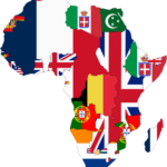
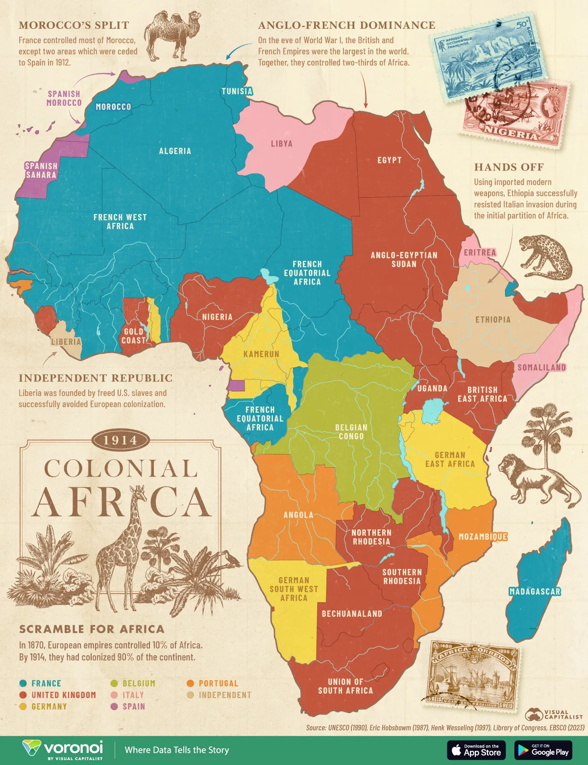
The conventional story says colonial borders were drawn hastily in Europe, especially during the Berlin Conference of 1884–1885, where European powers partitioned Africa. That is true. But stopping there misses a more important truth: colonial powers did not simply divide land; they divided power, identity, memory, and the possibility of future unity.
This essay argues that the partition of African peoples was not only an administrative convenience. It functioned as a strategic system of fragmentation designed to reduce the capacity of Africans to organize across ethnic, religious, linguistic, and territorial lines. The Hausa case—split between British Nigeria and French Niger—provides a powerful lens through which to understand this broader pattern.
The Real Meaning of “Divide and Conquer”
The phrase “divide and conquer” is often treated as a slogan. In political theory, however, it is a precise strategy:
A ruler prevents unified resistance by ensuring that potential rivals remain separated, suspicious of one another, or dependent on different centers of authority.
The Romans used it among tribes. European empires applied it globally. In Africa, it took a territorial form. The colonial state did not need every ethnic group to hate each other; it only needed them to lack a single political platform powerful enough to challenge imperial authority.
The logic was simple:
1. Identify large, influential populations.
2. Prevent them from existing within one sovereign political unit.
3. Place different sections under different colonial systems.
4. Develop separate administrative cultures, educational systems, and political loyalties.
5. Leave the borders intact at independence so the fragmentation survives the empire.
This was not always written in one explicit document saying “split this ethnic group.” Empires often acted through strategic calculations about security, trade routes, taxation, and rivalry with other European powers. Yet the cumulative effect was the same: fragmented African political space.
The Hausa Example: One People, Two Colonial Worlds
Before colonial conquest, Hausa-speaking societies formed a broad commercial and cultural zone across what is now northern Nigeria and southern Niger. Cities such as Kano, Katsina, Zaria, and Maradi were linked by trade, Islamic scholarship, marriage networks, and shared language.
Then came partition.
* Britain incorporated much of the southern Hausa region into Northern Nigeria.
* France incorporated much of the northern Hausa region into Niger.
The consequences were profound:
Under British Rule
* Indirect rule through emirs
* Expansion of English-language administration
* Integration into a larger Nigerian political economy
* Different legal and educational structures
Under French Rule
* Stronger emphasis on direct administration
* Promotion of French language and civic assimilation
* Integration into the French West African federation
* Different bureaucratic and political traditions
The same ethnic group entered two different political civilizations.
A Hausa trader in Kano and a Hausa trader in Maradi could speak the same language, pray in the same mosque tradition, and share ancestry, yet they were governed by different laws, educated in different languages, taxed differently, and later became citizens of different states.
This is the essence of colonial fragmentation: shared identity was preserved culturally but separated politically.
Why Multi-Ethnic States Were Advantageous to Colonial Powers
Colonial administrators often preferred larger territories containing multiple groups because such territories created intermediate dependencies. If no single group could dominate easily, colonial authorities became the ultimate arbiters of power.
In Nigeria, Britain brought together hundreds of ethnic communities, including Hausa-Fulani, Yoruba, Igbo, Tiv, Kanuri, Ijaw, Nupe, Jukun, and many others. The resulting state was not merely diverse; it was structurally dependent on a central authority to manage competing interests.
The political effects included:
* Competition for access to colonial administration
* Regional political identities
* Differential educational development
* Ethnicized representation
* Reliance on colonial mediation
By the time independence arrived, many African elites inherited states whose internal cohesion had never been organically negotiated by their populations.
The Berlin Conference: The Moment of Cartographic Power
The Berlin Conference (1884–1885) did not partition every inch of Africa on a finished map, but it established the rules by which European powers claimed territory. African representatives were not invited. Rivers, trade routes, military advantage, and European rivalries mattered more than existing African political realities.
The result was a map where:
* The Somali were divided among British Somaliland, Italian Somaliland, French Somaliland (Djibouti), Ethiopia, and Kenya.
* The Ewe were divided between British Gold Coast (Ghana) and French Togo.
* The Bakongo were divided among Angola, Congo, and the Democratic Republic of Congo.
* The Tuareg were divided across Mali, Niger, Algeria, Libya, and Burkina Faso.
* The Hausa were divided between Nigeria and Niger.
The pattern is too widespread to dismiss as coincidence.
Was the Division Always Intentional? A Necessary Red-Team Test
A rigorous analysis must challenge itself. Critics argue that:
* Colonial borders were often drawn with limited knowledge.
* Europeans prioritized economic concessions and strategic geography, not ethnic fragmentation.
* Many pre-colonial African states were themselves multi-ethnic.
* Some ethnic groups remained largely intact within single colonies.
These points are valid. Overstating intentionality weakens the argument. The strongest conclusion is not that every border was consciously designed to split every ethnic group, but that colonial powers consistently accepted, exploited, and institutionalized fragmentation whenever it served imperial interests.
In other words, the outcome was systematically divisive even when the process was not perfectly planned in every case.
The Post-Colonial Trap: Why the Borders Survived
At independence, African leaders faced a dilemma. Redrawing borders to match ethnic realities could have triggered endless wars. In 1964, the Organization of African Unity (OAU) adopted the principle of respecting inherited colonial borders. Stability was prioritized over historical correction.
This decision avoided immediate continental chaos, but it also froze colonial geography into international law. The consequences remain visible:
* Cross-border insurgencies
* Ethnic nationalism
* Secessionist movements
* Disputes over resource control
* Conflicts where ethnic communities straddle borders
Nigeria’s civil war (1967–1970), Tuareg rebellions in the Sahel, Somali irredentism, and many other conflicts cannot be explained solely by colonial borders, but those borders formed the structural stage on which later politics unfolded.
The Deeper Logic: Fragmentation as Geopolitical Insurance
The most overlooked aspect of colonial partition is its future-oriented logic. A fragmented region is easier not only to conquer, but also to influence after formal empire ends. When neighboring states contain related populations, external powers can engage each state separately, negotiate different security arrangements, and prevent the emergence of a single continental power center.
Consider the Hausa region today:
* Nigeria and Niger cooperate, yet each has its own security priorities.
* Cross-border trade flourishes, but customs regimes differ.
* Religious and cultural ties remain strong, but political authority is divided.
* Militancy, migration, and economic shocks often spill across the border, requiring bilateral rather than unified responses.
The border did not erase Hausa identity; it multiplied the number of states through which that identity must be negotiated.
That is a subtler and more enduring form of control.
A Comparative Snapshot
Aspect
Before Colonial Partition
After Colonial Partition
Territorial unity
Contiguous cultural zone
Split across colonies
Political authority
Local emirates and networks
British vs. French administrations
Language of government
Hausa and Arabic traditions
English vs. French
Legal system
Indigenous and Islamic institutions
Separate colonial legal systems
Economic orientation
Regional trade networks
Different colonial markets
National identity
Primarily regional/cultural
Nigerian vs. Nigerien citizenship
Long-term effect
Potential broader political cohesion
Permanent cross-border negotiation
The 80/20 Insight: The Few Facts That Explain Most of the Outcome
If we apply an 80/20 analytical lens, a small number of facts explain most of the modern consequences:
20% of the Causes
* Berlin Conference rules
* Rivalry between Britain and France
* Partition of major ethnic zones
* Different colonial administrative systems
* Retention of colonial borders after independence
80% of the Effects
* Multi-ethnic states
* Cross-border identities
* Regional political competition
* Language-based elite formation
* Persistent debates over national unity
* Security challenges that ignore borders
What This Means for Nigeria Today
Understanding colonial fragmentation does not mean denying Nigerian nationhood. Nations can be built from diversity; India, Indonesia, and the United States demonstrate that multi-ethnic states can endure. The lesson is different: Nigeria’s diversity was not assembled through a voluntary constitutional convention of its peoples. It was assembled through imperial cartography and later inherited by Nigerians.
Therefore, successful nation-building requires conscious effort in areas where colonialism left fractures:
* Inclusive federalism
* Fair resource distribution
* Inter-ethnic trust-building
* Cross-border economic cooperation
* Education that teaches shared history rather than competing myths
Blaming every contemporary problem on colonialism is intellectually lazy. Ignoring colonialism altogether is historically blind. Mature analysis holds both truths simultaneously.
Final Reflection: The Border as a Political Technology
The most important conclusion is this: a border is not merely a line separating territories; it is a technology that shapes who cooperates with whom, who pays taxes to whom, who learns which language, and who imagines themselves as part of which political community.
The Hausa were not destroyed by partition. They remain one of Africa’s largest cultural communities. But colonial partition transformed a potentially unified political space into a shared civilization spread across multiple sovereignties.
That transformation captures the larger African experience. European empires often governed not by eliminating African identities, but by rearranging them into configurations that reduced the likelihood of unified power. The map of Africa is therefore not only a record of conquest; it is a record of strategic fragmentation whose consequences continue to shape politics, security, and identity in the twenty-first century.
The enduring question is not whether the lines were arbitrary. The deeper question is why those arbitrary lines have proven powerful enough to outlive the empires that drew them.
By Ibrahim Bunu
Email: ibrahimbunu2520@gmail.com