By Okoi Obono-Obla
Cross River State and the Evolution of Nigeria’s Geopolitical Zones-
Surely, Cross River State is the most south-eastern state in Nigeria, both geographically and historically. In 1967, when states were created, three states were carved out of the Eastern Region of Nigeria: East Central State (comprising present-day Abia, Anambra, Ebonyi, Enugu, and Imo States), South Eastern State (comprising present-day Akwa Ibom and Cross River States), and Rivers State (comprising present-day Bayelsa and Rivers States).
In 1976, another state creation exercise increased the number of states in Nigeria from 12 to 19. The military leadership then decided to rename South Eastern State as Cross River State, instead of creating another state from it, despite demands from the people of Calabar and Ogoja. Later, in 1988, Akwa Ibom State was carved out of Cross River State under General Ibrahim Babangida’s administration.
By November 26, 1993, General Sani Abacha toppled the Interim National Transitional Government set up by Babangida after the annulment of the June 12, 1993 presidential election, widely believed to have been won by Chief Moshood Kolawole Abiola. A Lagos High Court had declared the Interim Government unconstitutional, creating a leadership vacuum that Abacha filled.
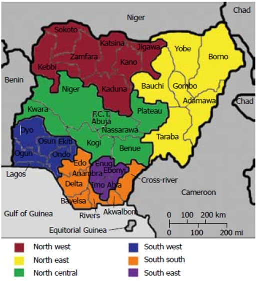
During Abacha’s regime, amidst growing agitation for democracy and restructuring, a National Constitutional Conference was convened. At this conference, Dr. Alex Ekwueme, former Vice President of Nigeria (1979–1983), made a compelling case for restructuring Nigeria into six geopolitical zones: North West, North East, North Central, South West, South East, and South South. His proposal grouped ethnic minority areas of the old Mid-Western Region (Delta and Edo States) and the old Eastern Region (Akwa Ibom, Cross River, and Rivers States—Bayelsa was not yet created) into the South South zone. The military adopted this structure, though the term “South/South” remains geographically awkward.
Therefore, when one refers to South Eastern Nigeria in its true geographical and literal sense, it essentially means Akwa Ibom and Cross River States—the most southerly states in Nigeria’s eastern axis.
Conclusion:
Cross River State’s historical evolution reflects Nigeria’s complex journey of state creation, geopolitical restructuring, and the quest for balanced representation. While political nomenclature has shifted over time, geography affirms Cross River and Akwa Ibom as the true South Eastern states of Nigeria.


Leave a comment